East New Market
Historic Sketches
2010 - Frank S. Collins
In progress... (creating a small book, instead of a web based story)
The History of East New Market
From the Beginning to the Great Fire of 1914
by Frank S. Collins
The first European ownership of land in the area that would later be known as East New Market occurred on 14 August 1675 when Thomas Taylor patented a 1,010 acre tract called “Bath.” This tract encompassed an area that stretched from the present day town of Secretary, Maryland, to East New Market. The northern boundary of the tract followed a branch of Secretary Creek then known as "Fort Branch". The plat map below show the boundaries of "Bath" compared to a present day satellite map.
[insert here - deedmapper plat of Bath superimposed over a google maps image]
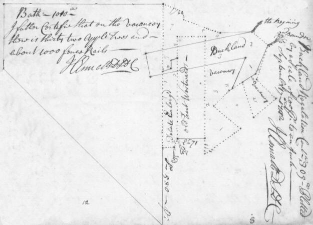
In the 1680s, three more tracts were patented that comprised land that would later become East New Market. On 1 January 1681, William Smithson patented a 200 acre tract called “York.” The northwest corner of this tract began at a Hickory Tree that was close to where Friendship Hall now stands. The Hickory was described as being on the "Nanticoke Indian Path from the Choptank Indian Fort". The next day on 2 January 1681, Edward Taylor patented a 100 acre tract called "Westward". This southwest corner of this tract began at the same Hickory Tree as "York". A year later on 20 April 1682, Thomas Pattison patented a 150 acre tract called "Buckland". The surveyor must not have been aware of the earlier patents, as this tract overlapped a small part of the "Bath" tract and bisected the north part of the "Westward" tract. To rectify the error the tract was resurveyed in 1744 and renamed "Buckland Regulated" as shown in the plat below.
The Delmarva Peninsula was occupied by Native Americans for well over 5,000 years before the European discovery. When Europeans began recording deeds and claiming ownership of land in Dorchester County, there were numerous Indians living in the county. In early records the branch of Secretary Creek north of East New Market was known as “Fort Branch”. The Choptank Indian Fort was located somewhere along this branch, but the exact location is not currently known. The most likely location is somewhere closer to the town of Secretary.
Existing recorded and archeological evidence, indicates that the land comprising East New Market likely had not been settled by Native Americans at the time that European settlers arrived. For the most part, Indian settlements on the Eastern Shore were usually closer to rivers and creeks, such as the village at Locust Point, west of Secretary. The mention of the "Nanticoke Indian Path from the Choptank Indian Fort" in early patents and deeds is a clear indication that Native Americans travelled through the local area.
In 1669 an Act of Maryland's General Assembly stated that local Indians are friends of the Maryland government and deserve of special treatment. The local Indians of the time were facing threats of encroachment and oppression by the English settlers. They also faced attacks by the Wiccomis Indian tribe and their allies. Maryland's proprietary government granted a large block of territory along the south bank of the Choptank River to three tribes of Indians, each identified by their leader, Ababco, Hatsawap, and Tequassino. The land stretched from Secretary Creek to the city of Cambridge.
Two deeds in 1726 and 1727 reveal a dispute about the ownership of the tract "Bath"
The land granted to the Choptank Indians included the tract "Bath", but did not include "Buckland", "Westward", or "York".
Bath back in Indian hands sold to English.
Thomas Taylor sold "Bath" along with "Addition to Bath" to his
brother "Peter Taylor" in 1702. Peter Taylor leased 1010 acres
"Bath" to Charles Rye in 1703 and sold a 100 acre part to his brother
Phillip Taylor in 1703 and 299 acres to Francis Anderton in 1704.
Buckland - 1683 - Patent Record SD A, p. 76
Westward - 1683 - Patent Record SD A, p. 361
York - 6 August 1683 - Patent Record CB 3, p. 363
Bath - 1675 - Patent Record 19, p. 316
Buckland - 1683 - Patent Record SD A, p. 76
Westward - 1683 - Patent Record SD A, p. 361
York - 6 August 1683 - Patent Record CB 3, p. 363
Debate Enlarged - 1732 - Patent Record PL 8, p. 703
Ridgy Land - 1739 - Patent Record LG B, p. 85
Carthagena - 1740 - Patent Record LG B, p. 132
Buckland Regulated - 1 March 1744 - Patented Certificates 595
Andertons' Desire - 1745 - Patent Record PT1, p. 126
Francis' Desire
Melvill's Meadows - 1746 - Patent Record BT and BY 3, p. 93
Sulivane's Meadows - 17 November 1756 - Patented Certificates 2861