East New Market
Property Reports
East New Market-Rhodesdale Road
Colored People's Methodist Episcopal Church
The tract below is the upper 17.5 acres of the 35 acre tract that Henry Nicols bequeathed to Sarah Young in 1832. The land is the original site of the Colored People's Methodist Episcopal Church (now Faith Community UMC Church). The Trustees of the Church purchased a new lot for the Church in 1880. With no need for the old site, in 1881 they sold the "piece of ground that the old M.E. Church once sit on". After several years of ownership by the Edmondson family, the land was sold to William T. Hubbard in 1948 and thus became part of the Hubbard Canning Company. When the Church purchased this property in 2002, they may not have realized the lot played a significant role in the history of the Church 144 years prior.
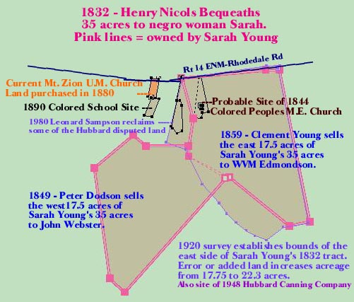
474 MLB 827 - 21 February 2002 - William T. Hubbard Family Limited Partnership to the Trustees of Mount Zion United Methodist Church for $225,000: Lot on the south side of Maryland State Route No. 14 (East New Market to Rhodesdale State Road) and situate on the north and east sides of a dirt road leading from Maryland State Rout No. 14 to the Mount Zion United Methodist Church Cemetery (77 MLB 153), known locally as "Mt. Zion M.E. Cemetery Road", containing 22.33 acres of land more or less and being that land shown and laid down on that certain plat entitled "Plat of a Part of the Land of Hubbard Canning Co." dated June 1975 in Plat Cabinet No. 47, 333-A. Save and except that certain 15,778 square foot parcel on plat entitled "Part of the Land of Hubbard Canning Co. to be conveyed to Leonard Sampson" dated January 1980 in Place Book Liber 26, folio 55, which was conveyed unto Leonard Sampson, et. ux, by Oliver W. Hubbard, Personal Representative, et al by deed dated 14 February 1980 in 218 PLC 325. The land to be conveyed is the land which was conveyed to the Grantor by deed dated 14 February 1980 in 219 PLC 50. See also deed of division dated 19 February 1977 in 199 PLC 95 between Frieda M. Richardson, and Richard Hubbard & William T. Hubbard, wherein Mt. Zion ME Cemetery Road was established as the common boundary line between the Richardson land and the Hubbard land.
 219
PLC 50 - 14 February 1980 - Richard P. Hubbard and Oliver W. Hubbard,
Personal Representatives of William T. Hubbard, deceased; Shirley D.
Hubbard, Richard P. Hubbard and Oliver W. Hubbard, surviving Directors
of Hubbard Canning Company; Richard P. Hubbard and Oliver W.
Hubbard, individually; to the William T. Hubbard Family Partnership:
Whereas by the third item of the Last Will and Testament dated 29 March
1962 in 9 DKL 322, William T. Hubbard, deceased, bequeathed unto his
sons, Richard P. Hubbard and Oliver W. Hubbard, equally, all of his
stock in Hubbard Canning Company, but prior to the death on 2 January
1979 of the said William T. Hubbard, the said Hubbard Canning Company's
charter had been forfeited; and whereas the parties of the second part
are the sold surviving Directors of said Hubbard Canning Company and are
authorized to convey its remaining assets, which assets include the
parcel of land hereinafter described. Parcel No. 2:
Lot which was granted unto William T. Hubbard by J.E. Dandridge Murdaugh
Jr., unmarried, by deed dated 1 October 1948 in 67 RSM 420.
219
PLC 50 - 14 February 1980 - Richard P. Hubbard and Oliver W. Hubbard,
Personal Representatives of William T. Hubbard, deceased; Shirley D.
Hubbard, Richard P. Hubbard and Oliver W. Hubbard, surviving Directors
of Hubbard Canning Company; Richard P. Hubbard and Oliver W.
Hubbard, individually; to the William T. Hubbard Family Partnership:
Whereas by the third item of the Last Will and Testament dated 29 March
1962 in 9 DKL 322, William T. Hubbard, deceased, bequeathed unto his
sons, Richard P. Hubbard and Oliver W. Hubbard, equally, all of his
stock in Hubbard Canning Company, but prior to the death on 2 January
1979 of the said William T. Hubbard, the said Hubbard Canning Company's
charter had been forfeited; and whereas the parties of the second part
are the sold surviving Directors of said Hubbard Canning Company and are
authorized to convey its remaining assets, which assets include the
parcel of land hereinafter described. Parcel No. 2:
Lot which was granted unto William T. Hubbard by J.E. Dandridge Murdaugh
Jr., unmarried, by deed dated 1 October 1948 in 67 RSM 420.
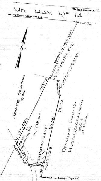
218 PLC 325 - 14 February 1980 - Richard P. Hubbard and Oliver W. Hubbard, personal representatives of William T. Hubbard, deceased, to Leonard Sampson & Marva Sampson, his wife: Whereas the parties have agreed to settle a boundary line dispute between them which was the subject of a civil case entitled "Hubbard Canning Company vs. Leonard Sampson et al." being No. 3850 Civil Law Docket, by establishing a new division or boundary line. The division line is more fully shown on the plat dated January 1980 entitled "Part of the Land of Hubbard Canning Co. to be Conveyed to Leonard Sampson" Beginning at an iron rod set in the westerly line of Parcel No. 2 described in a deed from William T. Hubbard and Shirley D. Hubbard to Hubbard Canning Company dated 27 August 1960 in 122 PLC 167 (said rod being at the most northerly corner of the herein described land and being also S12/03W 184f on the said westerly line of said Parcel No. 2 from a concrete monument at the intersection of said westerly line with the southerly side of the public road leading from East New Market to Shiloh, known as Maryland Highway 14, and from said place of beginning running with a new division line between the herein described land and the reserved land of Hubbard Canning Company the following courses S88/48E 27.74f to an iron rod, thence S19/01E 41.37f to an iron rod, thence S1/11E 196.58f to an iron rod, S64/07W 45.21f to an iron rod, thence N42/15W 50.70f to an iron rod, thence N42/15W 20.65f to the land of Leonard Sampson and the aforesaid westerly line of said Parcel No. 2, thence with said westerly line N12/03E 207.70f to the place of beginning. Containing 15, 778 square feet.
122 PLC 167 - William T. Hubbard & Shirley D. Hubbard, his wife, to the Hubbard Canning Company for $5: Parcel No. 2 - lot which was granted unto William T. Hubbard by J.E. Dandridge Murdaugh Jr., unmarried, by deed dated 1 October 1948 in 67 RSM 420. [land described in 67 RSM 420]. Supposed to be 17 3/4 acres.
67 RSM 420 - 1 October 1948 - J.E. Dandridge Murdaugh Jr., unmarried, of Franklin County, Pennsylvania to William T. Hubbard for $5: Lot in East New Market District. Beginning at a stone on the South edge of the State Road leading from East New Market to Rhodesdale, said stone is at the South end of the first culvert across said road, East of East New Market and at the beginning of the second line of a deed from L. Winfield Nichols and wife to Merritt W. Nichols, dated July 16, 1919 in 6 WHM 521, thence running with the second and third lines of said deed S11/5E 1227f to a stake at the end of the said second line, S80/50W 200f to a stone, S51/15W 164f to a stone to be placed on the East edge of a private road, thence running and binding with said private road the 7 following courses and distances N70/15W 98f, N57/30W 80f, N52/45W 100f, N47/30W 100f, N34W 100f, N42/30W 200f, N25/15W 300f to a stone to be placed on the West edge of the aforesaid private road, N69/20W 162f to a stone to be placed, N14/25E 516f to a stone on the South edge of the aforesaid State Road leading from East New Market to Eldorado, thence with the said edge of the State Road the two following courses N82E 660f, N87/30E 107f to the beginning. Containing about 17 3/4 acres. The land being the same land conveyed unto the said J.E. Dandridge Murdaugh Jr. by Emma E. Jacobs, unmarried, as Lot No. 1 in a deed dated 21 July 1948 in 66 RSM 581.
66 RSM 581 - 21 July 1948 - Emma E. Jacobs, unmarried, of New London County, Connecticut to J.E. Dandridge Murdaugh Jr. for $5: [land described in 67 RSM 420] Being the same land that was conveyed unto the said Emma E. Jacobs and Jean E. Jacobs by Frederick H. Fletcher, Trustee, by deed dated 15 June 1921 in 10 WHM 366, the interest and estate of the said Jean E. Jacobs having passed upon her death under her Last Will and Testament recorded in 3 RPS 95, unto William V.E. Jacobs and was conveyed by the said William V.E. Jacobs, bachelor, unto the above named Emma E. Jacobs, by deed dated 7 July 1925 in 16 JFD 536.
16 JFD 536 - 7 July 1925 - William V.E. Jacobs of New York City to Emma E. Jacobs for $1: his interest in "Preston Vale" at or near the depot at East New Market on the southern side of the State road leading from East New Market to Shiloh, supposed to contain about 17 3/4 acres, and which Emma V. Jacobs inherited from her father, W.V.M. Edmondson, (whose sole heir she was), and including a small parcel conveyed unto the said Emma V. Jacobs by Charles Hughes et. al., trustees of Zion M.E. Church, by deed dated 8 November 1881 in 4 CL 24. [land described in 67 RSM 420]
10 WHM 366 - 15 June 1921 - Frederick H. Fletcher, Trustee, to Jean E. Jacobs and Emma E. Jacobs for $2450. Whereas by decree of Court 28 February 1920 passed in a cause between Jean E. Jacobs and Emma E. Jacobs, complainants, and Edmund D. Murdaugh and others, defendants, in No. 3879 Chancery, the above named was appointed trustee to sell the real estate in the proceedings. All that lot called "Preston Vale" at or near the depot at East New Market on the Southern side of the State road leading from East New Market to Shiloh, supposed to contain about 17 3/4 acres, and which Emma V. Jacobs inherited from her father, W.V.M. Edmondson (whose sole heir she was), and including a small parcel conveyed unto the said Emma V. Jacobs by Charles Hughes et. al. Trustees of Zion M.E. Church, by deed dated 8 November 1881, in 4 CL 24, the whole being particularly described as follows: [land described in 67 RSM 420]
4 CL 24 - 8 November 1881 - Charles Hughes, John H. Thompson, Lewis H. Young, Draper Jackson, Thomas D. Pinder, James Ross, Moses Banks, John H. Camper, and Draper A. Jackson, Trustees of the Zion M.E. Church to Emma V. Jacobs for $10: lot in the Second Election District near the Depot of the Dorchester and Delaware Railroad and better known as being the same piece of ground which Clement Young sold to Dr. W.V.M. Edmondson. Being the same piece of ground that the old M.E. Church once sit on, said piece of ground measuring 20 x 30 feet and is bound on all sides at the present time by the lands of the said Emma V. Jacobs.
7 FJH 446 - 4 May 1869 - George L. Stevens & Susan A. Stevens, his wife, Mary F. Newton & Wilber F. Newton, her husband, Emily J.C. Stevens & George A.K. Stevens to John Webster for $67.50: Lot being a part of the same land which the said George L. Stevens, Mary F. Newton, Emily J.C. Stevens, and George A.K. Stevens took under the Will of John D. Stevens, and which John D. Stevens obtained from Wesley Sampson & wife by deed which is included in a survey made at the request of John Webster by George Winthrop dated 10 November 1866 of the lands purchased by him from Peter Dodson, free negro, and the land purchased by him in exchange with George Stevens. Containing 4 1/2 acres.
5 FJH 387 -4 June 1863 - Mary Sampson & Wesley Sampson, her husband, to John D. Stevens for $125: Lot bounded on the south by the lands of the said John D. Stevens, on the west by the lands of Thomas J. Hicks, being a part of tract called Preston Vale as reference to a deed from Elizabeth Carroll to John Thompson dated 30 April 1839. Containing 9 acres.
4 FJH 398 - 28 February 1859 - Clement Young & Rosette Young, his wife, to W.V.M. Edmondson for $400: lot in the vicinity of East New Market on the road leading from East New Market to Crotcher's Ferry formerly occupied by the said Clement Young & Rosette Young, his wife, being the same obtained by deed from a certain Peter Dodson & Rosetta Dodson, his wife, (excepting only that portion on which the colored peoples Church occupies and the space of ten feet all around). Containing 17 acres.
1852-1864 Tax Record for Dorchester County
Clement Young (negro)
house & lot 17 acres
1 horse $40, 1 hog $2
.....reduced
1859 by 17 3/4 acres land sold to W.V.M. Edmondson
William V.M. Edmondson
17 3/4 acres land from C. Young & wife $150
4 WJ 625 - 8 May 1849 - Peter Dodson & Rosetta Dodson, his wife, of Baltimore, to John Webster for $136: Tract of land called "Preston Vale" being part of a tract formerly belonging to Henry Nicols, deceased, who in his last Will and testament devised to a certain Sarah Young, negro, and being the same land that was deeded to the said Peter Dodson by a certain Clement Young & wife in 4 WJ 200-202. Beginning for the said part at a stone on a ditch bank & near a fence; the said stone is a bounder of John Websters' land, thence running S41/30W 71.75p to a fence, thence N47W 9.5p, N50E 24p, S50E 8p, E 20p to a fence, thence with the fence S1/30E 5p to the corner of said fence, thence with the said fence to the beginning. Containing 17 acres.
4 WJ 200 - 25 March 1848 - Clement Young & Rosetta Young, his wife,
to Peter Dodson, of Baltimore in consideration of other land:
(1) part of "Preston Vale" devised by last Will and Testament of Henry
Nicols, deceased, to Sarah Young, negro, and being the residue of said
which was deeded 16 July 1847 to Clement Young by Peter Dodson and wife.
Beginning for the said part at a stone on a ditch bank & near a fence;
the said stone is a bounder of John Websters' land, thence running
S41/30W 71.75p to a fence, thence with said fence N54W 9.5p thence N8W
52.75p, N50E 24p, S50E 8p, E 20p to a fence, thence with the fence
S1/30E 5p to the corner of said fence, thence with the said fence to the
beginning. Containing 17 acres.
(2) also a lot in the village of East New Market and adjoining the lots
of the Methodist E. Church and the New Market Academy, now in the
occupancy of Elisha Hollyday, being the same lot formerly belonging to
the aforesaid Henry Nicols, and who in his last Will and testament
devised it to Sarah Young, negro.
4 WJ 202 - 16 July 1847 - Peter Dodson & Rosetta Dodson, his wife, of Baltimore to Clement Young: Exchange of lands; all that part of a tract called "Preston Vale" being a part of that part of a tract formerly belonging to Henry Nicols, deceased, and who in his last Will & testament devised it to a certain Sarah Young, negro. Beginning at a stone on a ditch bank, and near a fence of John Webster's land, thence with the fence the original courses of the said part of the tract N51E 36.5p, thence N28/45(no E/W) 9.75p to the beginning of said part of land, thence N11/15E 23p to the county road, thence with that road W6.5p, thence S84/30W 40p, thence S16W 20p, thence S10W 13p, thence S1/30E 5p to the corner of a fence, thence with said fence to the beginning. Containing 17 3/4 acres together with the buildings (excepting the Methodist Meeting House and ground on which said house is erected).
2 WJ 523 - 1 November 1845 - George Young, free negro, to Peter Dodson, free negro of Baltimore City, for $30: right, title, and interest in all the tracts of land which the late Henry Nicols by his last will and testament dated 15 March 1832 in 2 WWE 129, "I give and bequeath unto my said negro woman Sarah, all that lot of ground with a small house thereon and containing about seven acres of land and lying back of the Methodist Meeting House, and I also give and bequeath unto said negro Sarah, a lot or parcel of land which I purchased of Jeremiah Bramble and adjoining the lands of Morris Roach, Henry Bradley and Daniel Sullivan, containing about 35 acres of land more or less. All of the said parcels of land I give and bequeath unto Sarah during her lifetime and after her decease I give and bequeath the same to negro girl Rosette who I here herein set free during her lifetime and after her death I give and bequeath the same to my negro Clem and negro George, children of the said negro Sarah, or the survivor of them and their heirs forever." Together with the improvements & appurtenances thereunto belonging.
2 WJ 114 - 20 August 1844 - Sarah Young, Rossett M Dodson & Peter Dodson, her husband, Clem Young & Rossett, his wife, and George Young to Jeffry Stanley, William Parker, Clem Young, Richard Moore, Peter Dodson, Charles Hughes, and Samuel Green, Trustees for the colored peoples Methodist Episcopal Church for East New Market circuit: Tract of land on south side of the county road leading from New Market to Crotcher's Ferry. Beginning at a post or stone standing in or near the line of a tract of land called "New Market" presently in the occupancy of Henry W. Hicks, Esq. and from thence runs S85E 3 3/4 perches, then N7E 3 1/2 perches, thence N85E 3 perches, then N12W 17 perches, to the above named county road, thence with said road 1 perch to the said tract called "New Market", thence with said tract to the place of beginning. Containing 30 square perches of land. The above described land is a part of a tract which Henry Nicolls, late of Dorchester County, Maryland, willed to the said Sarah Young, and in line to Rossett, Clem, and George, three of the said Sarah's children as referenced to said Will executed fifteenth day of March 1832
1838 Tax Assessment List, District 2, Dorchester County, Maryland
negro Sarah, late the slave of Henry Nicols Real Estate $310, Personal
Estate $125
Item - I give and bequeath unto my said negro woman Sarah, all that lot of ground with a small house thereon and containing about seven acres of land and lying back of the Methodist Meeting House, and I also give and bequeath unto said negro Sarah, a lot or parcel of land which I purchased of Jeremiah Bramble and adjoining the lands of Morris Roach, Henry Bradley and Daniel Sullivan, containing about 35 acres of land more or less. All of the said parcels of land I give and bequeath unto Sarah during her lifetime and after her decease I give and bequeath the same to negro girl Rosette who I here herein set free during her lifetime and after her death I give and bequeath the same to my negro Clem and negro George, children of the said negro Sarah, or the survivor of them and their heirs forever.
11 ER 350 - 16 July 1829 - Jeremiah Bramble to Henry Nicols for $250: Parcel of land called Preston Vale containing 35 acres. Beginning on the south side of the county road leading from New Market to Vienna running South bounded with Morris Roach land being part of said tract called Preston Vale and so continuing and binding line by line with said land until it intersects the land of Dr. Daniel Sullivane and running and binding therewith to the aforesaid county road and thence with said road to the place of Beginning and being the same land formally purchased by Thos Light of Eliz. Birckhead containing 35 acres and premises hereby bargained and sold.
11 ER 187 - 29 October 1828 - Elizabeth Birckhead to Jeremiah Bramble for $1400: Preston Vale
Dorchester County Court - October Term 1823 - Elizabeth Birckhead vs. Joseph Daffin, Susan Daffin, Charlotte Daffin, William Daffin, Henry Daffin, Charles Daffin, heirs at law of Charles Daffin. The bill of complaint shows that your orators father Doct Daniel Sulivane, late of the same county, did during his lifetime on 19 April 1788 purchase of a certain Charles Daffin for the sum of 250 pounds, two several tracts or parts of tracts situated in the said county, which are described as follows: All the land that the said Charles Daffin bought of John Brinsfield called Ridgy Land, except so much of the said tract called Ridgy Land as runs conveyed to James Sulivane by the said Charles Daffin and all the land that James Sulivane exchanged with the said Charles Daffin adjoining the aforesaid tract called Ridgy Land, containing 35 acres more or less. Since the execution of the said bond of conveyance the said Daniel Sulivane hath departed this life and by virtue of a division of the real estate of the said Daniel Sulivane, the said lands have been assigned to your orator, one of the daughters and heirs of the said Doct. Daniel Sulivane. Since the deed of execution both the said Daniel Sulivane and Charles Daffin have departed this life without making any conveyance of the said land. Charles Daffin leaving the following heirs at law, Susan D. Wilson, a daughter who lives in the city of Baltimore, Joseph Daffin, a son who resides without the state of Maryland, the children of Thomas Daffin, his son who is dead, namely Charlotte Daffin who resides in Baltimore, William who resides in Talbot County, and Henry and Charles both of who reside without the United States. The value of the purchase money has since been given for the same by the said Doct. Daniel Sulivane. All children of Thomas Daffin, the before named are minors under the age of 21.
19 April 1788 - Know all men by these Presents, that I Charles Daffin am hold and firmly bound unto Daniel Sulivane in the full and just sum of five hundred pounds gold or silver currency, to be paid unto the said Daniel Sulivane or his certain attorney, executors, administrators, or assigns, to that which payment will and truly to be made and done. I bind myself, my heirs, executors, administrators, and assigns in the whole and or the whole firmly by these presents, sealed with my seal and dated this nineteenth day of April, Seventeen hundred and Eighty Eight. The condition of the above obligation is such that if the above bound Charles Daffin, his heirs, executors, administrators, and assigns, do and shall well and truly convey, assign, and make over by a good of bargain and sale of apiese and indefeasible estate of inheritance in fee simple to the said Daniel Sulivane, his heirs and assigns at their reasonable request - all the land that the said Charles Daffin bought of John Brinsfield called Ridgy Land and all the land that James Sulivane exchanged with the said Charles Daffin adjoining the aforesaid tract called Ridgey Land containing thirty-six acres more or less avoiding the new courses of the said Lands then the above obligation to be void else to remain in full force and virtue in Law. Charles Daffin (seal), Signed, sealed, & delivered in the presence of Peter Young Hollon.