East New Market
Property Reports
7 Railroad Avenue
Joseph Buck Post Office
(Also known as the Seymour Property, Royal Lawns, and Choptank Distributing Company)
Key date analysis:
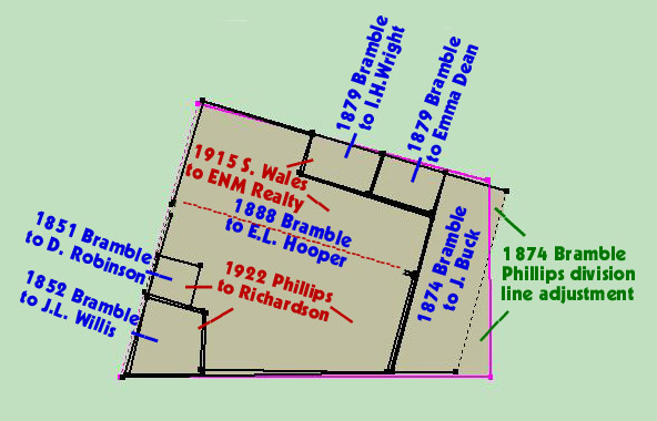
Joseph Buck purchased this property from Mary Bramble in 1874 and was operating a post office at this location by 1877. A tax record from 1875 reveals Joseph Buck built the structure at that time. The structure was torn down sometime after 1956.
Who built it:
Joseph Buck built the structure in 1875.
Longest Residents:
The Gambriel family owned the property for 32 years.
More Research:
Local residents may remember this structure and may have more photos.
Historic Records:
332 PLC 240 - 20 January 1996 - Choptank Distributing Company, successor to Rhodes Distributing Company to Brian J. Shufelt & Melissa D. Shufelt for $40,000: 7 Railroad Avenue; lot with improvements beginning for the same at a cross cut now set in the concrete sidewalk there situate on the south side of Railroad Avenue; southeast 158.26 feet from beginning of the first line of Lot No. 2 of the land which by deed dated September 6, 1941, RSM 43/448 was conveyed by County Corp. of Maryland to Clarence L. Saxton, Trustee for Choptank Lodge No. 138, Ancient, Free, and Accepted Masons; said point of beginning being also the northwest corner of the land which be deed dated 1 November 1966, PLC 149/267 was conveyed to Mary H. Webster, widow, to Ernest F. Shufelt and Catherine W. Shufelt, his wife, thence leaving said point running on the southerly line with a fence to a granite stone set as the first line being the same land which be deed was conveyed by Charles C. Powell & his wife, Beverly Powell to Choptank Distributing Company, Inc. This lot being part of the same property conveyed unto Rhodes Distribution Company, Inc. by deed from Choptank Distributing Company on 1 August 1973, 180 PLC 660.
180 PLC 660 - 1 August 1973 - Choptank Distributing Company to Rhodes
Distributing Company for $5: Parcel No. 1: north side of Railroad
Avenue, beginning at the outbounds of the same at the end of the
divisional line between the land hereby conveyed and the lands of the
late Charles H. Willis; thence running with the said line in a northerly
direction 60 feet, then westerly 40 feet, then southerly 60 feet, then
easterly 40 feet. Being the same property conveyed to Choptank
Dist. Co. by deed dated 21 April 1964, 138/32.
Parcel No 2.: stone set at the end of the 2nd line of the land by deed
dated 6 November 1963, PLC 136/15 was conveyed by Charles E. Edmondson,
Assignee of Mortgage, to Charles C. Powell, thence etc...; Being
the same property conveyed unto Choptank Distributing Company, Inc, by
deed from Charles C. Powell and Beverly F. Powell, his wife by deed
dated 15 October 1964, 140/112. Subject to the use in common with
others entitled thereto of the 12 foot alley extending southeasterly
from Main Street 123 feet along the land which by deed dated 6 November
1963, PLC 136/15 was conveyed by Charles E. Edmondson, Assignee of
Mortgage to Charles C. Powell.
Parcel No. 3: lot on south side of Railroad Avenue which by deed
dated 28 November 1969, 162/521 was conveyed unto Choptank Distributing
Company, Inc. by Ernest F. Shufelt, et al.
162 PLC 521 - 28 November 1969 - Ernest F. Shufelt & Catherine W. Shufelt, his wife, and Mary H. Webster, widow, to Choptank Distributing Company: Whereas the said Mary H. Webster, widow, did on 1 November 1966 convey her home property in East New Market to Ernest F. Shufelt & Catherine W. Shufelt, his wife, reserving unto herself a life interest in said property recorded in 149 PLC 267 has elected to relinquish her said life estate in this property and has joined the grantor in a conveyance to Choptank Distributing Company, Inc. and agrees to vacate and give up possession of said property on or before 1 March 1970. Beginning at a cross cut not set in the concrete side walk on the south side of Railroad Avenue; said point of beginning being located S73/30E 158.26f from the beginning of the first line of lot No. 2 of the land which by deed dated 6 September 1941 in 43 RSM 448 was conveyed by County Corporation of Maryland to Clarence L. Saxton, Trustee for Choptank Lodge No. 138, Ancient, Free, and Accepted Masons, said point of beginning being also the northwest corner of the land which by deed dated 1 November 1966 in 149 PLC 267 was conveyed by Mary H. Webster, widow, to Ernest F. Shufelt & Catherine W. Shufelt, his wife; thence leaving said point and running with the south side of Railroad Avenue and north line of the 2nd herein mentioned deed S73/30E 40f to the northeast corner of the 2nd herein mentioned deed; thence running and binding on the easterly line of said 2nd mentioned deed the three following courses, S16/13W .45f to a stone, thence continuing on the same course and in part with a fence S16/13W 111.55f to a pipe not set, thence continuing the same course S16/13W 2.34f to an old fence post at the southeast corner of said deed; thence binding on the southerly line of said deed with the fence S89/11W 40.83f to a granite stone at the beginning of the 1st line of the land which be deed dated 16 October 1964 in 140 PLC 112 was conveyed by Charles C. Powell & Beverly Powell, his wife, to Choptank Distributing Company, Inc., thence running and binding part of the first line of the 3rd herein mentioned deed N15/47E 126.5f to the place of beginning. Containing 4,746.53 square feet of land. Being all of the same land that was conveyed by deed dated 1 November 1966 from Mary H. Webster, widow, to Ernest F. Shufelt & Catherine W. Shufelt, his wife, in 149 PLC 267.
149 PLC 267 - 1 November 1966 - Mary H. Webster, widow to Ernest F. Shufelt & Catherine W. Shufelt, his wife, of Caroline County for $1: Lot in the town of East New Market. Beginning on the south side of the street leading from the Depot to Secretary, fronting said street 40 feet, and running back 125 feet, adjoining the lands formerly owned by James T. Smith on the east, Samuel E. Collins on the south, and Edward Hooper on the west. Being the same land which was conveyed unto Oliver A. Smith & Mabel Smith, his wife, by Mollie A. Smith, unmarried, by deed dated 30 September 1936 in 34 JFD 651; and also the same identical land conveyed from Oliver A. Smith & Mabel Smith, his wife, to D'Arcy E. Webster & Mary H. Webster, his wife, on 31 July 1948 in 66 RSM 500. The said D'Arcy Webster departed this life on 12 August 1965. Whereas his widow, Mary H. Webster, became sole owner.
66 RSM 500 - 31 July 1948 - Oliver A. Smith & Mabel Smith, his wife, of Prince George's County, to D'Arcy E. Webster & Mary H. Webster, his wife, for $5: [as described in 149 PLC 267]. Being the same land which was conveyed unto Oliver A. Smith & Mabel Smith, his wife, by Mollie A. Smith, unmarried, by deed dated 30 September 1936 in 34 JFD 651.
34 JFD 651 - 30 September 1936 - Mollie A. Smith, unmarried, to Oliver A. Smith & Mabel Smith, his wife, or Prince George's County for $5: [as described in 149 PLC 267]. Being the same property conveyed by James R. Gambriel, his wife, et al. to the said Mollie A. Smith by deed dated 5 March 1927 in 20 JFD 552.
1930 Census
Dwelling #47, household of Milly A. Smith
20 JFD 552 - 15 March 1927 - James R. Gambriel & Elizabeth Gambriel, his wife, William T. Gambriel & Ada Gambriel, his wife to Mollie A. Smith for $450: [as described in 149 PLC 267]. Being the same property conveyed unto Mary A. Gambriel from Elihu Wheatley & wife by deed dated 14 December 1895 in 19 CL 660. It being the property that was conveyed to the said Elihu Wheatley by Charles C.M. Seymour & wife by deed dated 7 May 1889 in 12 CL 392 and also being the land that was conveyed to the said Charles C.M. Seymour by Joseph W. Buck & wife by deed dated 6 February 1880 in 2 CL 1. And being the property devised by the Last Will and Testament of the said Mary A. Gambriel, to Mamie or Mary Gambriel, her daughter,. Said Will being dated 11 April 1903 and recorded in 2 RPS 536, and by the death of the said Mamie or Mary Gambriel, unmarried, descended to the said James R. Gambriel and William T. Gambriel, her brothers, they being her only surviving heirs. Another brother Harry Gambriel having died before the death of the said Mamie or Mary Gambriel, unmarried, and without children and there being no other brothers or sisters or any offspring from them, the said James R. Gambriel and William T. Gambriel being the only heirs at law.
1920 Census
Dwelling #30, household of Mary Ann Gambril
1910 Census
Dwelling #41, household of Mary A. Gambriel, seamstress
1900 Census
Dwelling #264, household of Mary Gambrell, dress maker
1896-1910 Tax Record
Mary A. Gambriel
1896 - 1 lot in ENM on west side of street leading to the Depot 40x125
feet with improvements $500
1896 Tax
Record
Mary A. Gambriel
1 lot in the town of East New Market on the west side of the street
leading to the depot containing 40x125 with improvements $500
19 CL 660 - 14 December 1895 - Elihu Wheatley & Eliza Jane Wheatley, his wife, to Mary A. Gambriel for $500: lot in the town of East New Market. [as described in 149 PLC 267]. Being the same property conveyed to the said Elihu Wheatley by Charles C.M. Seymour & wife by deed dated 7 May 1889 in 12 CL 392 and also being the land that was conveyed to the said Charles C.M. Seymour by Joseph W. Buck & wife by deed dated 6 February 1880 in 2 CL 1.
12 CL 392 - 7 May 1889 - Charles C.M. Seymour & Mary J. Seymour, his wife, to Elihu Wheatley for $670: [as described in 149 PLC 267]. Being the same property conveyed to the said Charles C.M. Seymour by Joseph W. Buck & wife by deed dated 6 February 1880 in 2 CL 1
1880 Census
Possibly Dwelling #14, household of C.C.M. Seymour, Tailor
2 CL 1 - 6 February 1880 - Joseph W. Buck & Elizabeth E. Buck, his wife, of Baltimore, to Charles C.M. Seymour for $650. Lot in East New Market being on the south side of the road leading from the depot to Secretary Creek with 40 feet front and 125 feet deep and adjoining the lands of Dr. James R. Phillips on the east, Samuel E. Collins on the south, Mrs. Mary Bramble and F.H. Dean on the west. It being the same property which was conveyed to the said J.W. Buck by deed from Mrs. Mary Bramble and more fully described therein.
1876 Tax
Record
J.W. Buck
Dwelling & store house in ENM 1/8 acre $700
Goods, Wares, & Merchandise $100
1867-1876 Tax Record
Mary Bramble
1867 House and Lot $1500
reduced
1874 B lot to Joseph Buck $100
Joseph Buck
1874 Lot from Mary Bramble $100
1875 Improvements $600
9 FJH 491 - 17 August 1874 - Mortgage - Joseph W. Buck owing to Stephen Andrews $200: Two lots in the town of East New Market. (2) and the other lot 45 feet front and 125 feet deep, the above was bought of Mary Bramble and adjoining the Masonic Hall and Dr. James R. Phillips. The intention of this mortgage is that if the said Joseph W. Buck shall pay on or before 15 September 1876 the sum of $200 with interest or Stephen Andrews can sell the property to pay the debt.
9 FJH 225 - 3 January 1874 - Mary A. Bramble to Joseph W. Buck for $150: lot between the lot on which stands the residence of Dr. James R. Phillips and the lot on which stands the house known as the Drug store and a dwelling house of the said Mary Bramble. Beginning at a point six inches West of the office of the said James R. Phillips and running westward 40 feet thence southward 129 feet to the line of Samuel E. Collins, thence 40 feet eastward to the line of the said Dr. James R. Phillips and thence to the place of beginning.
[For pre 1874 information about this property, see the historic record report for the Bramble House, which was formerly at this location.]