East New Market
Property Reports
104 Main Street
Helsby Dwelling
Key date analysis:
In 1810 Samuel Corkran purchased a large lot from Henry King that included this site. He paid $75. In 1810, $75 was a typical price for a lot with little or no improvements. In 1841 Nimrod Newton purchased the property from Corkran for $400, which was a typical price paid at the time for property with a small frame house. In 1852, a tax record shows Helsby with a house & lot and storehouse valued at $800 at this location. A deed from 1865 states "said premises has been in the possession of the said Thomas Helsby from the year 1844". The premises in this context is more likely a dwelling rather than the land itself. A dwelling house was known to have stood on this property in 1874 when the lands of Thomas Helsby were divided.
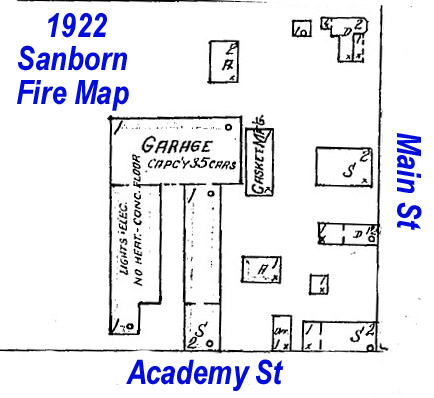
The structure built by Corkran between 1810 and 1841 was either the Newton Dwelling or this structure, the Helsby Dwelling. Since both structures are no longer standing and since I have not located a record that shows a construction date, I am not able to determine which house was erected first. The second house was likely built shortly after the owner acquired the property in the early 1840s. The dwelling house owned by Helsby in 1852 survived until the late 1920s. This small one-story dwelling house with a tin roof was shown on the 1922 Sanborn Fire Map.
Who built it:
The small frame dwelling was either built by Samuel Corkran shortly after he bought the property in 1810, or by Thomas Helsby shortly after he settled on the land in 1844. The house was torn down or moved between 1922 and 1934.
Longest Residents:
Members of Helsby/Smith family owned/occupied the property from 1844 to until it was moved or destroyed in the 1930s.
More Research:
Historic Records:
[For more information about the building that now occupies this property see the historic record page for the Hometown Pride Market & Deli.]
Death - Emma Helsby Smith - 15 October 1871 - 21 August 1937
31 JFD 211 - 3 April 1934 - Thomas W. Simmons, Trustee in No. 5470
Docket "W" Bankruptcy Division of the District Court of the United
States for the Federal District of Maryland, to Clarence L. Saxton &
Maria J. Saxton, his wife, for $410: Whereas, as certain Emma H.
Smith, was adjudged bankrupt by the court in No. 5740 Docket "W", and
Thomas Simmons was elected trustee to sell property for the benefit of
creditors. Whereas the said Emma H. Smith is married and her
husband living, whose name is James M. Smith, who was also adjudicated
as bankrupt on the same day as his wife. Two lots in East New
Market.
(Lot No. 1), being lot No 2 in the survey of the four lots
of Emma H. Smith, and being mentioned in the report of sales as "2-room
office, rear of store" and beginning at an iron pipe on the north side
of Railroad Avenue at the end of the first line of lot No. 1 in said
survey, which is the corner store property, and from thence binding with
the northward side of Railroad Avenue, N74/15W 36f to an iron pipe and
the land of Saxton & Parker; thence with said land N15/45E 52f to an
iron pipe, thence S74/15E 36f to an iron pipe and said lot No 1 in said
survey, the corner store property, thence with said last named lot and
the second line thereof, reversed, S15/45W 52f to the place of
beginning.
(Lot No. 2), being the vacant lot, adjoining Howard H. Willoughby, and
lot No. 3 in the survey of the Emma H. Smith four lots, and beginning at
an iron pipe on the westward side of Main Street, which is the third
line of lot No. 1 in said survey, or the corner store property, and from
thence N74/15W 94f, to an iron pipe and the land of Saxton & Parker, at
the end of the second line of lot No. 2 in said survey and Lot No. 1
herein; thence with the land of Saxton & Parker, N15/45E 66f to a stone,
thence S74/15E 94f to the west side of Main Street and a stone; thence
with the west side of Main Street S15/45W 66f to the place of beginning.
The said survey being made by Lawrence F. Simmons, Esq, County Surveyor
in the year 1932. The said lots being part of the property devised
unto the said Emma H. Helsby, now the said Emma H. Smith, by the last
will and testament of Nimrod Newton, deceased, which is now of record in
2 EWL 166.
1930 Census
Possibly dwelling #17, household of James M. Smith
12 JFD 280 - 9 November 1922 - Emma H. Smith & James M. Smith, her husband, to Charles V. Helsby for $5: Lot in the town of East New Market. Beginning at an iron stob on the west side of Main Street at a point 40 feet north of the southwest corner of the storehouse of the said Emma H. Smith located on the northwest corner of Main Street and Academy Street, and from said iron stob runs in a northward direction 79 feet with the west side of Main Street to the property of Howard H. Willoughby, conveyed unto him by the grantors, and thence with the same in a westerly direction 93 feet to the property of Saxton & Parker, conveyed unto them by the grantors, thence with same in a southern direction 79 feet to an iron stob 40 feet from the north side of Academy Street and from thence runs in a straight line, and parallel with Academy Street 93 feet to the place of beginning.
1920 Census
Possibly dwelling #73, household of W.L. Clifton, farm laborer
1910 Census
Dwelling #61, household of W.L. Clifton, odd jobs
In 1905 a deed for an adjacent property describes this property as "the dwelling formerly occupied by Cassidy C. Rawlings, and now occupied by William S. Clifton"
1900 Census
Possibly dwelling #284, the household of Cas Rawlings, shoe maker
1899-1901 Dorchester County Commercial Directory - East New Market
C.C. Rawlins, shoemaker
East New Market Cemetery
Helen Helsby d. 6 January 1897
1896-1897 Dorchester County Commercial Directory - East New Market
C.C. Rawlings, shoemaker
Marriage - ca 1890
James Marion Smith to Emma Helsby
1896-1910 Tax Record
Helen Helsby
1896 - 1 store house in ENM $1000
Dwelling & lot adjoining store house $600
2 small dwellings & lots near the store house $500
C.C. Rawlings
1896 - Stock of Goods $150
13 February 1901 - insolvent
1896 Tax
Record
Helen Helsby
1 store house & lot in East New Market $1000
C.C. Rawlings
Note of hand $50, Stock of goods $150
1894-1895 Dorchester County Commercial Directory - East New Market
C.L. Rawlings, shoemaker
1891-1892 Dorchester County Commercial Directory - East New Market
C.C. Rawlins, shoemaker
1887 Dorchester County Commercial Directory - East New Market
C.C. Rawlings, shoes
East New Market Cemetery
Causine Helsby d. 13 April 1881
1880 Census
undetermined
[Emma and Hellen were living in East New Market
district with James Dean]
[This Will refers to an adjacent lot]
2 EWL 166 - 1 May 1872 / 18 April 1876 - Will of Nimrod Newton -
Item 1 - I give and devise unto my wife Margaret, in addition
to her thirds of my personal estate, and the property held in her own
right at the time of her marriage and such as she by her own industry
has made since. The dwelling House and lot where I now live with
the adjoining house and lot now occupied as a dwelling and Post office
situated in the town of E. Newmarket during my said wife's natural life
only. And after the death of my said wife Margaret, I give and
devise all that said house and lot now occupied as a dwelling and Post
office to my Grandson Causine Helsby, to him, his heirs and assigns in
fee simple.
Item - and after the death of my said wife Margaret, I give
and devise, all that said house and lot where I now live to my great
grand daughter Emma Helsby to her heirs and assigns in fee simple.
1876 Tax
Record
Mrs. Helen Helsby
Dwelling house & lot in ENM 3/4 acre $800
[Helen Helsby was the widow of Frelinghusen Helsby and mother of Emma Helsby]
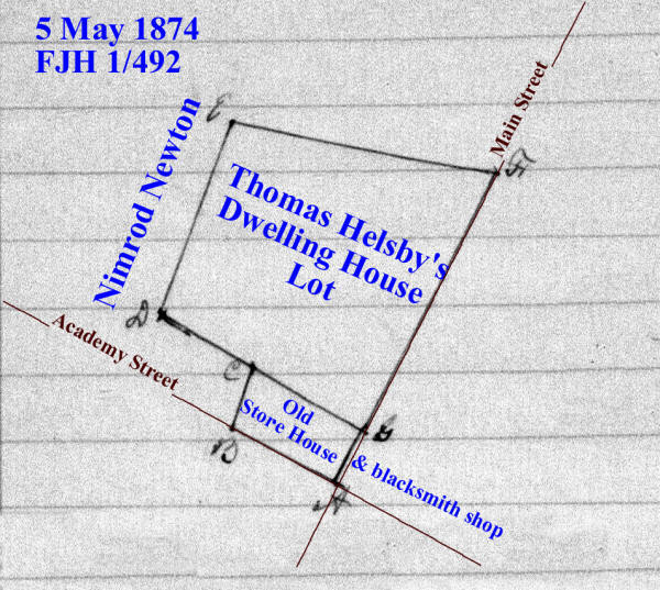
1 FJH 492 - 5 May 1874 - Causine Helsby to divide the lands of Thomas Helsby, deceased: A certain Thomas Helsby departed this life in the year 1865, intestate, and seized of certain real estate in the town of East New Market and leaving Frelinghuysen Helsby and your petitioner, the said Causine Helsby his only children and heirs at law, but the said Frelinghuysen Helsby departed this life, intestate, in the year 1872, leaving Emma Helsby his only child and heir at law, who is an infant under the age of 21 years. The petitioner prays that a commission fairly and equally in value between the parties interested. A commission of Kendall M Jacobs, John WM Dean, John W Fletcher, Thos K Smith, and Thos Leckie was appointed. The real estate situated in the town of East New Market consisting of a dwelling house & lot including an old store house & blacksmith shop on the same, and an arable lot of land detached from the dwelling house and lot and adjoining the school house in said town. Running a line from a stone on the Main Street straight to a stone near the fence of Nimrod Newton giving and allowing to Emma Helsby, infant child of Frelinghuysen Helsby, all of the lot and dwelling house and other buildings on the north of said straight line. To the said Causine Helsby, all that part of the house & lot above described lying on the south side of the line as above described running from the Main Street then intersecting with the said Nimrod Newton's fence including the old store house and blacksmith shop and also the lots of arable land detached as above described. (near the Episcopal Church of East New Market, beginning at the east corner of the primary school lot. )
1870 Census
Dwelling #
1867-1876 Tax Record
Sarah Jane Helsby
1867 - House & Lot $800
1867 - unimproved lot $150
1866 Tax
Record
Sarah Jane Helsby
house & lot $800, unimproved lot $150
East New Market Cemetery
Thomas J. Helsby - d. 10 September 1865 aged 53.
6 FJH 195 - 24 June 1865 - Nimrod Newton to Thomas Helsby for $300: lot in East New Market beginning at the north east corner of an old granary and noted on the plat by letter A, on the side of the county road leading to Cabin Creek and running from thence N73/15W 3p,3f to a lot formerly the property of Nancy McCollister, then with the said lot N18/30E 5p, then N73/15W 30f, then S18/30W to a small ditch, then with said ditch to the bank and fence between said lot and Nimrod Newton's garden, then with said bank and fence to the lot belonging to the heirs of Louisa LeCompte, the with said lot to the county road leading to Cabin Creek, then with said road to the place of beginning. Containing 5/8 of an acre. Said premises has been in the possession of the said Thomas Helsby from the year 1844.
1860 Census
Dwelling #788, household of Thomas Helsby, farmer
1852-1864 Tax Record
Thomas Helsby
House & Lot, Store House $800, unimproved lot 5 acres $125
1864 by abatement on house & lot in New Market $600
1850 Census
Dwelling #381, household of Thomas Helsba, wheelwright
Marriage - 27 March 1843 - Dorchester County
Thomas Helsby to Sarah J. Newton
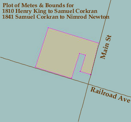
18 ER 237 - 4 February 1841 - Samuel Corkran & Elizabeth, his wife, to Nimrod Newton for $400: Beginning at a stone in the ground at the NE corner of an old granary in the village of East New Market, noted on the plat by a the letter A and running from thence N 73 W 3 perches & 3 feet to a lot formerly the property of Nancy McCollister, then with the said lot N 18 E 5 perches, then N 73 W 30 feet, then S 18 W 7 1/2 perches to the main road leading to the head of Secretary Creek Dickinsons landing, then with the said road N 73 W 11 perches, then N 18 E 12 perches to a post, then S 73 E 15 1/4 perches to the main road leading from New Market to Cabin Creek, then by said road to the beginning. Containing 1 acre.
27 HD 383 - 12 March 1810 - Henry King to Samuel Corkran for $75: Beginning at a stone set on the ground at the north east corner of an old Granary in the village of New Market, noted on the plat by the letter A, and running from thence North 73 degrees West 3 perches, and then set to Nancy McCollisters lot then with said lot north 18 degrees East 5 perches, then North 73 degrees West 30 feet, then South 18 degrees west 7 1/2 perches to the main road leading to the head of Secretary Creek, Dickinson's Landing, then with said road North 73 degrees West 11 perches, then North 18 degrees East 12 perches to a post, then South 73 degrees East 15 1/4 perches, to the main road leading from New Market to Cabin Creek then by said road to the beginning. Containing 1 acre.
20 HD 398 - 25 October 1802 - Commission Certificate to Joseph
Ennalls, John Stevens, Joseph Whiteley, Edward Whiteley and William
Ennalls, gentlemen. Henry King petitions the court that a certain John
Anderton Mitchell died intestate and seized of lands in Dorchester
County. Your petitioner and a certain Mary King, sister of your
petitioner, of full age, and a certain Mary King the only child and
daughter of a certain Edward King, who was a brother of your petitioner
and is now dead, are entitled to the said lands by inheritance as heirs
at law and representatives of the said John Anderton Mitchell, deceased.
The Mary King, last aforesaid, is a minor. Your petitioner therefore
prayed that the said court will appoint a commission to divide the
lands. Notice was given to Betsy King who the court appointed as
guardian of the said Mary King, who is a minor under the age of 21
years. The Commission estimated the value of the land at 3618 pounds and
divided it.
Re ---For Henry King, 3 parts valued at 1206 pounds:
(2) Beginning for the 2nd lot layed out for Henry King composed of
Sundry parts of tracts of land at the end of 58 perches on the second
line of the land that John Rix sold to John Anderton where stands a
cedar post as No. V at L on the plot and from thence, runs N 75 W 30
perches to another cedar post as No. VI at Q on the plot, then S 17 W
116? 1/2 perches to the main road that leads down to Henry Dickinson's
farm then S 75 E 29 1/2 perches until it comes parallel with the west
side of the granary then N 15 E 3 perches to a cedar post a No. VII at R
on the plot then S 75 E to the main road that leads from New Market to
Cabin Creek and then with the said road to the place of beginning.
Containing 9 1/4 acres.
Re ---for Mary King, daughter of Edward King, deceased, land valued at
1206 pounds
[Corner Store/Trinity Hall] (2) one other lot whereon the Granary
stands. Beginning for said lot at the end of the 3rd line of Henry Kings
9 1/4 acre lot and then runs N 15 E 8 perches to a cedar post as No. VII
at R on the plot, then S 75 E to the main road that leads from Cabin
Creek to Cambridge then S 15 W 18 perches to the main road that leads
from Crotcher's Ferry to Henry Dickinson's farm and then with a straight
line to the place of beginning. Containing 9 square perches of land.
25 Old 9 - 13 June 1771 - Francis Anderton, planter, to John Anderton, merchant, for 10 pounds and a tract called "Sandwich" in the forks of Cabin Creek's branches: (3) Also part of a tract called "Buckland" and part of a tract called "Debate Enlarged", being the land granted by a certain John Rix to the aforesaid John Anderton, deceased. Beginning at the end of 6p in an E course drawn from a marked live oak standing in the edge of a swamp in the fork of Secretary's Creek, being the beginning tree of said John Anderton, deceased, his part of a tract called "Bath", then runs still E 32p, then N 172 1/2p, then E 3p, then N to the branch, then binding with the branch until it intersects a N course from the beginning. Containing 50 acres. John Anderton, deceased, is the father of said Francis Anderton.
11 Old 200 - 29 June 1743 - John Rix to John Anderton in consideration of 50 acres of land lying in the fork of Secretarys Creek being a part of a tract of land called "Westward" as by deed bearing equal date with there presents may more fully appear: land being a part of "Buckland" and part of "Debate Enlarged". Beginning at the end of 6p in an east course drawn from a marked live oak standing in in the leg of a swamp in the fork of Secretarys Creek, being the beginning of said Andertons part of a tract Bath, then runs still East 32p, then N 172 1/2p, then E 3p, then N to the branch, then binding with the branch until it intersects a north course from the beginning. Containing 50 acres.