East New Market
Property Reports
5 Academy Street
Saxton & Parker
(Also known as Saxton Hardware Store)
Key date analysis:
In 1852, a tax record shows Nimrod Newton with a house & lot valued at $200. This was one of the lowest valued houses in East New Market at the time. The house on this lot in 1852 was either the Newton Dwelling or the Helsby Dwelling. Since I have not located a record that shows a construction date, I am not able to determine which house was erected first. The first house was likely erected by Samuel Corkran between 1810 and 1840 and the second house was likely built shortly after the owner acquired the property in the early 1840s. The dwelling house owned by Helsby in 1852 survived until the late 1920s. This small one-story dwelling house with a tin roof was shown on the 1922 Sanborn Fire Map.
In 1860, Newton made $150 in improvements to a shop on his property. The assessed value of $350 continued to be one of the lowest valued properties in town. When Nimrod Newton wrote his Will in 1872, he notes his dwelling House and lot where I now live with the adjoining house and lot now occupied as a dwelling and Post office. Two structures appear on the 1877 map next to the name of Mrs. Newton at this location. The tax records for 1866 through 1876 continue to list a house, shop, and lot for Nimrod Newton and the value increases to $400 and later to $500.
The 1896 tax record shows Helen Helsby with 1 storehouse worth $1000, and 1 dwelling house & lot adjoining the store house worth $600, and 2 small dwelling houses near the store house worth $500. The Helsby Corner Store was built in 1882 and thus is the storehouse listed in 1896. If the store to become Saxton & Parker existed in 1896, the store was either referred to as a small dwelling or was omitted in the tax records (unlikely).
Is it possible the structure on the 1877 map in the approximate location of the Saxton & Parker store is indeed this store and the tax records missed listing it? All structures referred to as stores and shops in the 1896-1910 tax record for East New Market are accounted for. Each store and shop can be clearly be associated with another property. Since the value of the store on Newton's and later Saxton's property was so low and since the Saxton & Parker building was large and impressive store, it is believed that the building on the 1877 map could be the Smith Tax Office as this office could be referred to as a small dwelling. Therefore, it is believed the Saxton & Parker store could have been built after 1910.
The first entry for Saxton & Parker appears in the 1915-1917 Commercial Directory for East New Market along side an entry Clarence Saxton, blacksmith and agricultural implements. Dating back to the 1906 directory, only Saxton was listed with "blacksmith and agricultural implements". Saxton began leasing part of this property in 1905, but he may have built the Saxton & Parker Store several years later.
Who built it:
Based on the available records at present, it is believed the store was possibly built by Clarence Saxton around 1914.
Longest Residents:
More Research:
More records likely exist that would shed more light on the time frame when the Saxton & Parker store was constructed or moved to this location. Newspaper items and court cases would be the best place to start. Dendrochronology could also establish the exact date of date of construction of this structure.
Historic Records:
[1,2]439 MLB 652 - 28 December 2000 - L.B. Adshead Family Limited
Partnership to Leonard D. Zeller & Christine M. Zeller, his wife, for
$45,000: Two parcels on the north side of Academy Street, also
formerly known as Railroad Avenue or School Street in East New Market.
[1] Parcel One - Lot on the north side of Railroad Avenue,
described in a deed to Albert L. Pennypacker from Clarence L. Saxton &
Maria J. Saxton, his wife, dated 20 March 1947 in 61 RSM 663.
Beginning at a point on the north side of Railroad Avenue, at a distance
of 134 feet in a S74/15E direction, from the southwest corner of the
brick store building formerly owned by Jacob Millenson, the said store
building being situated at the northeast corner of Railroad Avenue and
Main Street, and from said point runs N15/45E 197.2 feet to an iron pin,
from thence N76/22W 87.2 feet to another iron pin, from thence S15/45W
194.4 feet to another iron pin on the north side of Railroad Avenue, and
from thence with the said Railroad Avenue S74/15E 87.2 feet to the place
of beginning. Excepting therefrom that lot conveyed by the said
Albert L. Pennypacker & Maud H. Pennypacker, his wife, to Lawrence E.
Adshead & Thelma Adshead, his wife, by deed dated 11 October 1952 in 79
RSM 430 and being described as follows. Lot with improvements
thereon on the east side of School Street, formerly known as Railroad
Avenue, in the town of East New Market, and described according to a
certificate of survey made by John C. Fisher, Surveyor, dated 18 August
1952 as follows. Beginning at an iron bolt planted in the ground
on the east side of School Street and the north side of a driveway,
thence N25E? 130 feet to another iron bolt, thence N64W 36 feet to an
iron pipe planted in a ditch on the boundary line dividing the property
herein intended to be conveyed and the land reported to be owned by Fred
Willoughby, thence with the said Fred Willoughby lot, S25W 130 feet to
another iron bolt on the east side of school street, thence with the
same S64E 36 feet to the place of beginning. Containing 4680
square feet.
[2] Parcel Two - Lot with improvements on the east side of School
Street, formerly known as Railroad Avenue in the town of East New Market
described in a certificate of survey made by John C. Fisher, Surveyor,
dated 18 August 1952. Beginning at an iron bolt on the east side
of School Street and north side of a driveway, thence with the north
side of said driveway, N25E 130 feet to another iron bolt, thence N64W
36 feet to an iron pipe planted in a ditch on the boundary line dividing
the property herein intended to be conveyed and the land reported to be
owned by Fred Willoughby, thence with the said Fred Willoughby lot, S25W
130 feet to another iron bolt on the east side of school street, thence
with the same S64E 36 feet to the place of beginning. Containing
4680 square feet.
Together with a right of way for the benefit of the land
herein intended to be conveyed for all purposes of ingress and egress,
over a 10 foot driveway as now in existence, running adjacent to and
adjoining the first course herein given throughout its entire length.
Being the same land conveyed unto the grantor as "tract one, parcel one"
and as "tract two" by deed dated 23 March 2000 in 423 MLB 943.
423 MLB 943 - 23 March 2000 - Lawrence B. Adshead (also known
as Lawrence Blake Adshead and Larry B. Adshead) to L.B. Adshead Family
Limited Partnership for $0:
[1] Tract One Parcel One - [described as Parcel One in 439
MLB 652]
Tract One Parcel Two - [See 24/26
Main Street and adjacent properties on South Main St]
[2] Tract Two - [described as Parcel Two in 439
MLB 652] Being the lands conveyed unto Larry B. Adshead by
deed of Lawrence E. Adshead dated 30 December 1982 in 225 MLB 302.
Tract Three - Tract on the northwestern side of Maryland
Route 16 in the East New Market Election District which according to
survey made by Evans, Hagan, & Holdefer Inc., Surveyors and Civil
Engineers, dated 6 July 1976 in 18 PLC 45. Beginning at a point in
the westerly right of way of Maryland Route 16, 15 feet from and
measured at right angles to the center line of said road as now
constructed and thence leaving said right of way and running for new
lines of division through the land which by deed dated 4 May 1959 in 114
PLC 285 was conveyed to Margaret Stevens Greenwood to Lawrence E.
Adshead and Thelma B. Adshead, his wife, of which the parcel now being
described is a part, the two following courses N56/30W 350.37 feet to a
pipe now set passing over a pipe 5 feet from the beginning of said line,
N32/45E 206.71 feet to a pipe now set, thence continuing said course
N32/45E 6.5 feet to the center line of a 3 foot wide stream there
situate, for a total distance of 213.2 feet, thence in a southeasterly
direction with the meanderings of said stream 355 feet to the center of
a 48 inch reinforced concrete pipe culvert and to the aforesaid westerly
right of way line of Maryland Route No. 16, thence running with said
right of way line 15 feet from and measured at right angles to the
center line of said road as now constructed S32/45W 274.26 feet to place
of beginning. Being the lands conveyed unto Lawrence B. Adshead by
deed of Lawrence E. Adshead dated 30 August 1976 in 196 PLC 445.
[north of East New Market]
Tract Four Parcel Number 1 - on the east side of north main
street at edge of town
Tract Four Parcel Number 2 -
[2] 225 PLC 302 - 30 December 1982 - Lawrence E. Adshead to Larry B. Adshead for $0: [described as Parcel Two in 439 MLB 652] Being the same land which was conveyed unto Lawrence E. Adshead & Thelma Adshead, his wife, by deed from Albert L. Pennypacker & Maud H. Pennypacker, his wife, dated 11 October 1952 in 79 RSM 430. Upon the death of Thelma E. Adshead title to said property vested absolutely in the said Lawrence E. Adshead by virtue of the right of survivorship.
[2] 79 RSM 430 - 11 October 1952 - Albert L. Pennypacker & Maud H. Pennypacker, his wife, to Lawrence E. Adshead & Thelma Adshead, his wife, for $5: Lot with improvements on the east side of School Street, formerly known as Railroad Avenue in the town of East New Market described in a certificate of survey made by John C. Fisher, Surveyor, dated 18 August 1952. Beginning at an iron bolt on the east side of School Street and north side of a driveway, thence with the north side of said driveway, N25E 130 feet to another iron bolt, thence N64W 36 feet to an iron pipe planted in a ditch on the boundary line dividing the property herein intended to be conveyed and the land reported to be owned by Fred Willoughby, thence with the said Fred Willoughby lot, S25W 130 feet to another iron bolt on the east side of school street, thence with the same S64E 36 feet to the place of beginning. Containing 4680 square feet. Being a part of the same land that was conveyed to the said Albert L. Pennypacker from Clarence Saxton & Maria J. Saxton, his wife, by deed 20 March 1947 in 61 RSM 663.
[2] 61 RSM 663 - 20 March 1947 - Clarence Saxton & Maria J. Saxton, his wife, to Albert L. Pennypacker for $5: [described as Parcel Two in 439 MLB 652] Being the same land that L. Otis Corkran, Trustee in Bankruptcy, conveyed unto the said Clarence L. Saxton & Maria J. Saxton, his wife, by deed dated 20 June 1936 in 35 JFD 120. And for the same consideration, the said Clarence L. Saxton & Maria J. Saxton, his wife, transfer unto the said Albert L. Pennypacker, all of the stock of merchandise now in said store building where the said Clarence L. Saxton has been conducting the hardware business, and all of the following trade fixtures and equipment: 1 brown stand, 2 fire extinquishers, 1- 5 ft. showcase, 1- 10 foot counter, 1- 3 paper racks, 1 cash register, 1 small bin, 1 set counter scales, 500 hardware shelf boxes, 1 set seed scales, 2 seed bins, 1- 16 ft. table, 1 floor truck, 60 garden fork hooks, 9 chairs, 1 stove, 2 tables, 1 desk, 1 file, 1 oil stove, 1 case 20 drawers, 25 light fixtures, 1- 30 ft. counter and nail bins, 1 set platform scales, 2- 8 ft. counters, 1 glass board, 2 sets seed bins, 1 set pipe 1/8 to 3/4 inches, 1 pipe cutter, 1- 5 gallon can, 2 electric fans, floor trucks, counter brushes and brooms, 1 radio, 3 loose leaf ledgers, 1- 1 stock book, 1 set pipe dyes, 1 pipe cutter, 1 pipe vice, together with the good will of said business, and the said Clarence L. Saxton & Maria J. Saxton, his wife, do agree not to engage in the hardware business in said vicinity for the space of five years.
[2] 35 JFD 120 - 20 June 1936 - L. Otis Corkran, Trustee in bankruptcy to Clarence L. Saxton & Maria J. Saxton, his wife, for $1000: Whereas on 11 April 1932 Clarence L. Saxton and Harry E. Parker, trading as Saxton & Parker were adjudged bankrupt by the District Court of the United States for the Federal District of Maryland in No. 6797 Bankruptcy Docket "W", in 28 JFD 700; And whereas in July 1932 at the regular, legal meeting of the creditors of the said bankrupts, the said L. Otis Corkran was duly elected Trustee; And whereas in February 1936, he conveyed property at private sale by the Trustee unto Clarence L. Saxton & Maria J. Saxton, his wife, which sale was reported and ratified on 23 March 1936. Lot on the north side of Railroad Avenue in the town of East New Market. [described as Parcel Two in 439 MLB 652]. Being the same land that was conveyed by deed to the said Clarence L. Saxton and Harry E. Parker, co-partners, trading as Saxton & Parker, from Emma H. Smith & James M. Smith, her husband, dated 4 October 1919 in 7 WHM 94.
1930 Census
undetermined
1920 Census
undetermined
[1,2] 7 WHM 94 - 4 October 1919 - Emma H. Smith & James M. Smith, her husband, to Clarence L. Saxton and Harry E. Parker, co-partners, trading as Saxton & Parker for $700: Lot on the north side of Railroad Avenue in the town of East New Market. Beginning at a point on the north side of Railroad Avenue at a distance of S74/15E 134 feet from the west corner of a brick store building formerly owned by Jacob Millenson, the said store building situated at the east corner of Railroad Avenue and Main Street, from thence runs N15/45E 197.2 feet to an iron pin there planted, thence N76/22W 87.2 feet to another iron pin, thence S15/45W 194.4 feet to the north side of said Railroad Avenue and an iron pin, and from thence S74/15E 87.2 feet with the north edge of said Railroad Avenue to the place of beginning. Being the same land that was devised unto the said Emma H. Smith, by the last will and testament of Nimrod Newton.
[1,2] 3 WHM 307 - 2 January 1917 - Emma H. Smith & James M. Smith, her husband, to Clarence L. Saxton and Harry E. Parker, partners trading as Saxton & Parker for $700: Lot in the town of East New Market beginning at the north side of Railroad Avenue at a distance of 134 feet in a S74/15E direction from the west corner of the brick store building owned by Jacob Millenson, which said store building is situated at the east corner of Railroad Avenue and Main Street, then runs N15/45E to an iron pin, thence runs N76/22W 87.2 feet to another iron pin, thence runs S15/45W 194.4 feet to the north side of Railroad Avenue and and iron pin, and thence runs S74/15E 87.2 feet with the north edge of said Railroad Avenue to the place of beginning. The land above described was devised to the said Emma H. Smith by Nimrod Newton by Will. The said purchase price is to be secured by two promissory notes payable in twelve and twenty-four months, and for $350 each. Upon payment the said parties agree to convey the land. This land is subject to a lease for 99 years by the said Emma H. Smith & husband to the said Clarence L. Saxton, dated 15 January 1907 in 32 CL 583.
1915-1917 Dorchester County Commercial Directory - East New Market
Saxton & Parker, general store & repair shop.
[2] 6 CL 169 - 6 June 1913 - William W. Reid & Edith M. Reid, his wife, to Harry E. Parker for $5: An undivided half interest in a lot in the village of East New Market on the road leading from East New Market to the village of Secretary. Beginning at the southwest corner of a lot on which the storehouse formerly occupied by Thomas J. Helsby, but at present occupied by A.C. Humphreys, and thence running in a westerly direction 55 feet, binding with said road, thence in an northerly direction, and at right angles with said road 65 feet, thence in a westerly direction and parallel with said road 30 feet, thence in a northerly direction and at right angles with said road 135 feet, thence in an easterly direction and parallel with said road 85 feet, thence in a southerly direction 195 feet to the place of beginning. Being the same land that was leased unto Clarence L. Saxton by Emma H. Smith & James M. Smith, her husband, by lease dated 15 January 1907, in 32 CL 583; and including the land described in a deed from Howard J. Phillips & Lena M. Phillips, his wife, to the said Clarence Saxton, dated 15 February 1905 in 30 CL 319. And being likewise the same property which was conveyed unto the said William W. Reid by the said Clarence L. Saxton & wife, by deed dated 27 December 1912 in 5 WLR 350.
[2] 5 WLR 350 - 27 December 1912 - Clarence L. Saxton & Maria A. Saxton, his wife, to William W. Reid for $1500: An undivided 1/2 interest in said property. Beginning at the southwest corner of the lot on which the store house formerly occupied by Thomas J. Helsby, but at present occupied by A.C. Humphreys, thence running in a westerly direction 55 feet, binding with the road, thence in a northerly direction, and at right angles with said road 65 feet, thence in a westerly direction and parallel with said county road 30 feet, thence in a northerly direction and at right angles with said road a distance of 135 feet, thence in an easterly direction and parallel with said road a distance of 85 feet, thence in a southerly direction and at right angles with said road 195 feet to the place of beginning. Being the same land that was leased unto the said Clarence L. Saxton by Emma H. Smith & James M. Smith, her husband, by lease dated 15 January 1907 in 32 CL 583 and including the land described in a deed from Howard J. Phillips & Lena Phillips, his wife, to the said Clarence L. Saxton, dated 15 February 1905 in 30 CL 319. The aforegoing description of the property is the same as the property described in the lease unto the said Clarence L. Saxton by Emma H. Smith & James H. Smith, her husband, by lease dated 15 January 1907 in 32 CL 583.
1910 Census
undetermined
Denton Journal - 30 January 1909
- Personal and Social News
Mr. Clarence L. Saxton and Miss Maria Jones were married at East New
Market on the 27th
[2] 32 CL 583 - 15 January 1907 - Emma H. Smith & James M. Smith, her husband, lease to Clarence L. Saxton in the consideration of the payment of rent: Lot in the village of East New Market on the road leading from East New Market to the village of Secretary, beginning at the southwest corner of a lot on which the storehouse formerly occupied by Thomas J. Helsby, but at present occupied by A.C. Humphreys, and thence running in a westerly direction 55 feet, binding with said road, thence in a northerly direction, and at right angles with said road a distance of 65 feet, thence in a westerly direction and parallel with said county road 30 feet, thence in a northerly direction and at right angles with said road a distance of 135 feet, thence in a easterly direction and parallel with said road 85 feet, thence in a southerly direction and at right angles with said road a distance of 195 feet to the place of beginning. Being a part of the same lot that was devised unto Emma H. Helsby, now Emma H. Smith, by the last will and testament of Nimrod Newton in 2 EWL 166, also being a part of the property where Nimrod Newton lived at the time of his death. For the term of 99 years the yearly rent of $25.
[1] 30 CL 319 - 18 February 1905 - Howard J. Phillips & Lena M. Phillips, his wife, to Clarence L. Saxton to $575: Parcel in the town of East New Market on the road leading from East New Market to Secretary Creek. Beginning at the southwest corner of the lot on which the store house formerly occupied by Thomas J. Helsby stands, and west of the shop occupied by George W. Elliott, running thence with the street leading to Secretary Creek 40 feet, thence running back on a square with said road 85 feet, thence running on a parallel line with said road 40 feet to the line of the storehouse lot, thence a distance of 85 feet to the place of beginning. Being the same parcel granted unto Howard J. Phillips by deed dated 11 August 1904 in 29 CL 551. Subject to the payment of annual rent of $20.
[1] 29 CL 551 - 11 August 1904 - William S. Wright & Linda E. Wright, his wife, to Howard J. Phillips: [Described in 30 CL 319] Being the same land granted unto William S. Wright by deed dated 16 December 1903 in 28 CL 655.
[1] 28 CL 655 - 16 December 1903 -Levenia A. Rook & Robert M. Rook, her husband, to William S. Wright for $375: [Described in 30 CL 319] Being the same land granted unto Lavenia A. Rook by deed dated 30 August 1901 from Ella Chares & Arthur M. Charles, her husband.
[1] 25 CL 720 - 13 August 1901 - Lease - Emma H. Smith & James M. Smith, her husband, to Lavenia A. Rook in consideration of annual rent of $20: Parcel in the town of East New Market. Beginning at the southwest corner of the lot on which the store house formerly occupied by Thomas J. Helsby stands, and west of the shop occupied by George W. Elliott, running thence with the street leading to Secretary Creek 40 feet, thence running back on a square with said road 85 feet, thence running on a parallel line with said road 40 feet to the line of the storehouse lot, thence a distance of 85 feet to the place of beginning. Being the same property described in a deed from William E. Johnson, surviving administrator of Edward W. Reed, deceased, to Walter E. Bonner, by deed 22 CL 126. The right, title, and interest of the said Walter E. Bonner in said property being afterward to wit: On January 28 1901, by deed granted unto Ella Charles in 25 CL 153. Lease for a term of ten years.
[1] 25 CL 153 - 28 January 1901 - Walter E. Bonner & Margaret Bonner, his wife, to Ella Charles for $600: parcel in the town of East New Market on the road leading from East New Market to Secretary Creek. Beginning at the southwest corner of the lot on which the store house formerly occupied by Thomas J. Helsby stands, and west of the shop occupied by James R. Stevens and running with the road leading to Secretary Creek 40 feet, thence running back and square with said road 85 feet, thence running parallel with said road 40 feet to the line of the said store house, thence 85 feet to the place of beginning. This being the same property at present occupied and used by Arthur M. Charles as a Blacksmith shop. This being also the same property which by lease dated 1 January 1889 to be recorded among the land records of Dorchester County, was leased unto Edward W. Reed by Emma H. Helsby. Being the same land described in a deed from William E. Johnson, surviving administrator of Edward W. Reed, deceased, to the said Walter E. Bonner in 22 CL 126. Lease for the annual payment of $25.
1900 Census
undetermined
[1] 22 CL 126 - 9 February 1898 - William E. Johnson, surviving administrator of Edward W. Reed, deceased, to Walter E. Bonner: Whereas William E. Johnson and Richard H. Stevens, administrators of Edward W. Reed, deceased, sold to Walter E. Bonner all the interest of the said Edward W. Reed in the property and leasehold estate hereinafter described on 29 September 1896. Whereas the purchase money was paid, but the administrators failed to convey by good and sufficient deed for that purpose. Richard H. Stevens, one of the aforesaid administrators hath died, leaving William E. Johnson as surviving administrator. Parcel in the town of East New Market on the road leading to Secretary Creek. Beginning at the southwest corner of the lot on which the store house formerly occupied by Thomas J. Helsby, but occupied at present by W. Albert Henry stands, and west of the shop occupied by James R. Stevens and running with the road leading to Secretary Creek 40 feet, thence running back and square with said road 85 feet, thence running parallel with said road 40 feet to the line of the said store house, thence 85 feet to the place of beginning. This being the same property at present occupied and used by the said Walter E. Bonner as a blacksmith shop. This being also the same property which by lease dated 1 January 1889 to be recorded among the land records of Dorchester County was leased unto the above named Edward W. Reed by Emma H. Helsby. Lease for the annual payment of $25.
1896-1910 Tax Record
Helen Helsby
1896 - 1 store house in ENM $1000
Dwelling & lot adjoining store house $600
2 small dwellings & lots near the store house $500
Edward W. Reed
1896 -
Blacksmith shop on North side of Street from ENM to Secretary $300
1 old house in rear of shop $5
20 May 1898 - reduced by Blacksmith Shop to W.E. Bonner
W.E. Bonner
20 May 1898 - Blacksmith Shop from E.W. Reid $300
3 January 1898 - reduced by Blacksmith Shop to A.M. Charles $300
Robert Rook
19 May 1903 - Blacksmith Shop from A.M. Charles $300
10 May 1904 - reduced by Blacksmith Shop to Wm S. Wright
Mary A. Elliott
1 house on leased land on Railroad Ave. $25
5 May 1910 - reduced by house on leased land to C.L. Saxton
C.L. Saxton
26 April 1907 - House on leased land Railroad Avenue ENM from Mary A.
Elliott $25
6 May 1907 - Blacksmith shop from Wm S. Wright $300
1896 Tax
Record
Helen Helsby
1 store house & lot in East New Market $1000
1 Dwelling house & lot adjoining the store house $600
2 small dwelling house lots near the store house $500
[1] 1 January 1889 - Lease - Emma H. Helsby to Edward W. Reid. Annual Payment of $25
East New Market Cemetery
Margaret Newton 10 April 1885 aged 81 years, wife of Nimrod.
East New Market Cemetery
Causine Helsby d. 13 April 1881
1880 Census
Dwelling #9, household of Margaret Newton
1876 Tax
Record
Margaret Newton
Dwelling house, shop, & lot in ENM 3/4 acre - $500
Edward W. Reed
Stock in trade in Blacksmith Shop - $50
Cambridge Chronicle - 8 July 1876
- Notice to Creditors -
Notice is hereby given, that the subscriber hath obtained from the
Orphan's Court in Dorchester County, in Maryland, letters testamentary
on the personal estate of Nimrod Newton, late of Dorchester County,
deceased. All persons hereby having claims against the said
deceased are hereby warned to exhibit the same, with the vouchers
thereof, to the subscriber on or before December 6, 1876, otherwise they
may by law be excluded from all benefit of the said estate. All
persons indebted to said estate are requested to make immediate payment.
Francis A. Newton, executor of Nimrod Newton, deceased.
2 EWL 166 - 1 May 1872 / 18 April 1876 - Will of Nimrod
Newton
Item 1 - I give and devise unto my wife Margaret, in addition
to her thirds of my personal estate, and the property held in her own
right at the time of her marriage and such as she by her own industry
has made since. The dwelling House and lot where I now live with
the adjoining house and lot now occupied as a dwelling and Post office
situated in the town of E. Newmarket during my said wife's natural life
only. And after the death of my said wife Margaret, I give and
devise all that said house and lot now occupied as a dwelling and Post
office to my Grandson Causine Helsby, to him, his heirs and assigns in
fee simple.
Item - and after the death of my said wife Margaret, I give
and devise, all that said house and lot where I now live to my great
grand daughter Emma Helsby to her heirs and assigns in fee simple.
Easton Gazette - 15 April 1876
- Dorchester
Mr. Nimrod Newton, postmaster at East New Market, died on Sunday night
last, aged 84 years
History of East New
Market - 1871-1913 by Frank E. Loomis
The postmaster was Nimrod Newton, a good man, but something of a moss
back. To illustrate; about this time the M.E. Church decided to have
music in the worship, and place an organ in the church. This incensed
the old man for he believed the devil was in that organ. He was too
good to leave the church, so he concluded to separate the good from the
bad by remaining outside until the second hymn was sung, then go in and
come out before the last hymn. One day he made a mistake and reached
the "Amen Corner" before the second hymn was announced. He was in a
dilemma, but something had to be done at once. They were going to play,
so he got up and walked down the aisle and out of the church and
remained outside and remained outside until the music stopped, then he
returned. Mr. Newton's attitude may seem puritanical, but he was not
alone in his views as to the introduction of church music; thousands of
other persons held the same opinion.
1870 Census
Dwelling #361, household of Nimrod Newton, postmaster
1867-1876 Tax Record
Nimrod Newton
1867 - House, Lot, & Shop $400
1867 - Stock in Trade Lumber $75
1866 Tax
Record
Nimrod Newton
House, Lot, & Shop $400, Stock in trade goods $75
Cambridge Herald - 30 October
1861
Nimrod Newton, Postmaster at East New Market
1860 Census
Dwelling #758, household of Nimrod Newton, Wheel Wright
1852-1864 Tax Record
Nimrod Newton
House & Lot $200
1860 improvements on shop $150
1850 Census
Dwelling #
Cambridge Chronicle – 31 May 1845
– Sheriffs Sale
By virtue of a writ of Fieri Facias issued by
Nimrod Newton, Esq. a Justice of the Peace
for Dorchester county and to the Sheriff directed, at the suit of Thomas
K. Smith, against the goods and chattels, lands, and tenements of
William Moore I have seized and taken into execution the following
property of the said Moore to wit: one sorrel mare, the tract of parcel
of land upon which he now lives and also the tract or parcel of land
upon which Jno N. Moore and
Mary Moore (widow) now lives let the said tracts be known by whatever
names they may or contain whatever number of acres they may; and I
hereby give notice that I will sell to the highest bidder for cash at
Robinson’s Hotel in East New Market on Thursday, the 27th of June next,
all the right, title, interest, and claim, both at law and in equity of
the said Moore, to the said property thus seized and taken into
execution to satisfy the writ & costs. James E. Douglass, Deputy
Sheriff.
Cambridge Chronicle - 23 March
1844
John F. Henry, administrator of John Barrow, mentions Chancery suits of
William V.M. Edmondson, Nimrod Newton, and
James Wallace.
Marriage - 27 March 1843 - Dorchester County
Thomas Helsby to Sarah J. Newton
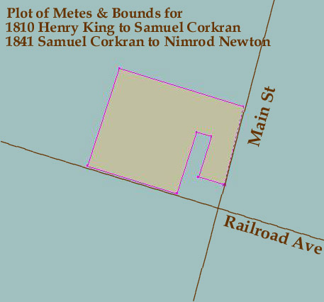
18 ER 237 - 4 February 1841 - Samuel Corkran & Elizabeth, his wife, to Nimrod Newton for $400: Beginning at a stone in the ground at the NE corner of an old granary in the village of East New Market, noted on the plat by a the letter A and running from thence N 73 W 3 perches & 3 feet to a lot formerly the property of Nancy McCollister, then with the said lot N 18 E 5 perches, then N 73 W 30 feet, then S 18 W 7 1/2 perches to the main road leading to the head of Secretary Creek Dickinsons landing, then with the said road N 73 W 11 perches, then N 18 E 12 perches to a post, then S 73 E 15 1/4 perches to the main road leading from New Market to Cabin Creek, then by said road to the beginning. Containing 1 acre.
Cambridge Chronicle – 20 December
1834 – Settle Debts –
Henry T. Barrow having removed to Buck Town, requests those indebted to
him to call & settle with Nimrod Newton, New
Market, who is authorized to settle accounts standing on his books.
27 HD 383 - 12 March 1810 - Henry King to Samuel Corkran for $75: Beginning at a stone set on the ground at the north east corner of an old Granary in the village of New Market, noted on the plat by the letter A, and running from thence North 73 degrees West 3 perches, and then set to Nancy McCollisters lot then with said lot north 18 degrees East 5 perches, then North 73 degrees West 30 feet, then South 18 degrees west 7 1/2 perches to the main road leading to the head of Secretary Creek, Dickinson's Landing, then with said road North 73 degrees West 11 perches, then North 18 degrees East 12 perches to a post, then South 73 degrees East 15 1/4 perches, to the main road leading from New Market to Cabin Creek then by said road to the beginning. Containing 1 acre.